
A mountain, a myth, an endless number of facets At 3798 metres, the Grossglockner is the highest mountain in Austria and at the same time the centre of the Hohe Tauern National Park, the biggest National Park in Austria. For many summiteers, the Glockner is a sought-after summit. Yet the mountain is also a habitat for people, animals and plants. And above all that, the Grossglockner is shrouded in mystery, steeped in legend and hugely appealing.
| Großglockner Facts | |
|---|---|
| Altitude | 3798 m |
| Location | Border of Carithia / East Tyrol, Austria |
| Mountain ranges | Glockner group / Hohe Tauern |
| Rocksn | Prasinit |
| First ascent | 28th July 1800 |
| Stand-out feature | Highest mountain in Austria |
Energy-filled space shrouded in myth and steeped in legends
The Glockner is indeed the highest mountain in the East Alps, but it is so much more than that. Numerous myths and legends are entwined around it – the stories about its name and first ascent alone could fill entire books! It is an energy-filled space and its mysteriousness is alluring. It is also often known as the ‘Brother of the Kailash’, and just like that sacred mountain, in days past was encircled by pilgrimage paths. However it matters not from which aspect or stories you approach the ‘Majesty’, the Grossglockner, either to revere it, go around it, or scale its summit – its impressive appearance is something that escapes no-one.

Names make mountains
The name ‘Glocknerer’ was first mentioned in a map created by Viennese cartographer Wolfgang Lazius, dating from 1561. The first documentary reference of the mountain name ‘Glogger’ came from a boundary description from the General Court in Kals, dating from 1583. In later maps, the name appeared as ‘Glöckner Mons’ and ‘Glöckelberg’. In the Atlas Tyrolensis (ca. 1760-1770) it is listed as ‘Glockner Berg’. This was the basis of its name, which consequently became prevalent, later to become the universally known Grossglockner.
Theories on the origins of the name
There are many theories as to where the description ‘Glockner’ comes from. Which one do you think is the most convincing?
- The bell shape theory
The mountain owes its name to its bell-like shape. - The cape theory
The name derives from the shape of a closed cape from the 15th century which had been known as ‘Glocken’. - The bellwether theory
The bellwether of a sheep herd is colloquially known as the ‘Glogga’. And because the Grossglockner is, as the highest mountain of the ‘leaders’ in its surrounding area, it became known as the Glogga. - The dialect theory
Glockner can be derived from the dialect word ‘klocken’. This means something like ‘thunder’ or ‘crashing about’, which in turn could be related to the sounds of ice- and rockfall on the mountain flanks. - The Slovenian theory
A derivation from the old Slovenian word ‘Klek’ is also thought to be a possibility; it was commonly used to describe a pointed peak.
The Grossglockner in the course of the millennia
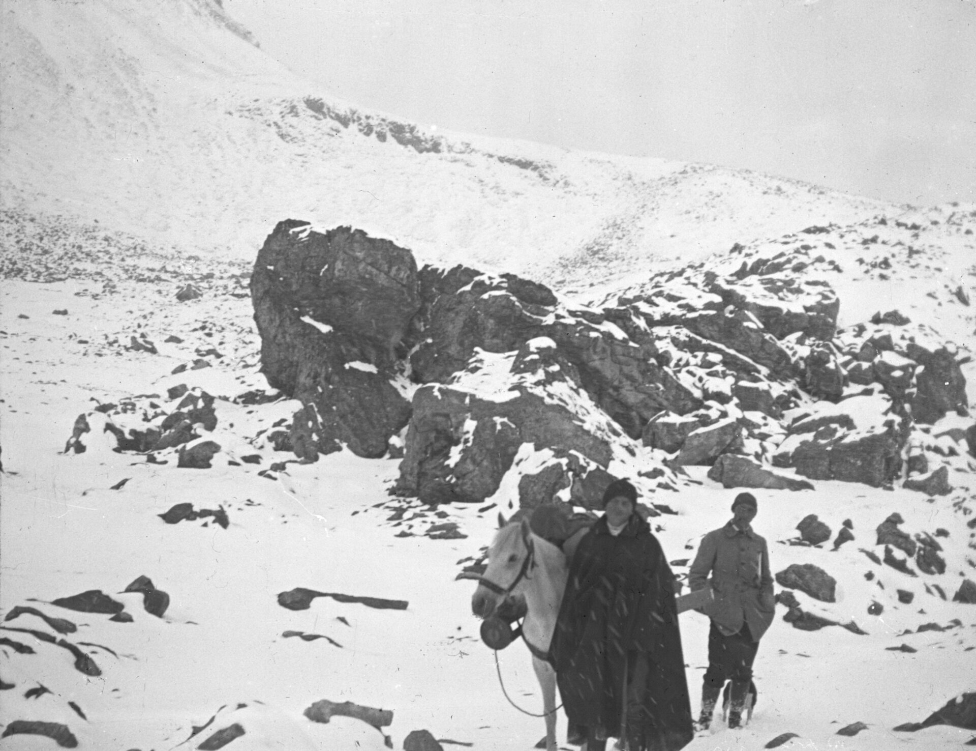
Historic finds confirm that even 5000 years ago people were crossing the Alps! Trade, the search for gold, minerals and new routes from north to south took people over passes. Legends and myths were entwined around spirits and witches in the lofty heights, and people asked the gods for safe passage. These finds can be seen in the ‘Passheiligtum Hochtor’ exhibition. With the start of the Enlightenment period in the 18th century, researchers and natural scientists set out to explore unknown mountain realms. Without maps, signposted paths, mountain bothies, routes, suitable equipment or even experienced mountain guides, courageous men and women made their way into the mountains. Alpinists followed in their footsteps …
The first ascent ot the highest mountain in Austria
Promoters and drivers with economic interests were not just Europe’s dynasties, so too was the high clergy. Two groups who had education and financial means. And so it was that Carinthian Archbishop Franz Xaver Count from Salm-Reifferscheid was the first to set about climbing the Grossglockner. He had the Salmhütte set up as a base at 2644 m. On 28th July 1800, five mountaineers reached the Glockner summit via Adlersruhe and placed the first summit cross.

BERG, DIE
The Grossglockner is female!The exhibition ‘Berg, die (Substantiv, feminin) – Frauen im Aufstieg’ is dedicated to the female aspect of the Grossglockner. The story of the first official female ascent in August 1869, by British woman Mary Whitehead and Salzburg woman Anna von Frey. Yet the assumption too that local women were likely on the summit of the Glockner much earlier is also a topic of this exhibition.

The scientific aspect of the Grossglockner
On behalf of Archbishop Count from Salm-Reifferscheid they also devoted themselves to science. The summit of the Grossglockner was measured geographically and in height, which resulted in a deviation of a few metres in view of the fact that the Adriatic Sea did not have a zero point. Experiments with snowmelts, boiling points of water, air humidity and heart rate and breath rates provided new findings too. A barometer was also positioned next to the summit cross, which provided data for 52 years. The total costs of the first ascent of the Glockner may have amounted to at least 50,000 Euro.

Glockner summit cross is a listed monument
On 2 October 1880, the Austrian Alpine Club (ÖAK) erected a three-metre-high, 300-kilo iron cross on the summit of the Grossglockner to mark the 25th anniversary of the marriage of Emperor Franz Joseph I and Empress Elisabeth of Austria. To mark the 200th anniversary of the first ascent of the Glockner in 1800, the historic object was flown down to the valley in a spectacular operation in 2000 and restored with the support of GROHAG. The Glockner Cross has been a listed building since 8 February 2024 due to its historical, artistic and cultural significance. This makes it not only the first such object to be granted this protected status by the Austrian Federal Monuments Office, but also Austria's highest monument!

A mountain as a sporting challenge
As well as scientific interest, people’s romanticisation of the mountains and the notion of a sporting challenge, brough increase numbers to the Grossglockner. The establishment of the Glocknerhaus in 1876 fundamentally shortened the ascent to the summit. Then people searched for alternative routes to tackle the summit - Margrave Alfred Pallavicini ascended the ice chute, named after him, from the Pasterze. In June 1886 he dies trying to ascend the Glocknerwand. Even Emperor Franz Joseph hiked up the Pasterze in 1856.
30 paths to the Glockner summit
Did you know that in literature, more than 30 different routes have been described to head up the Grossglockner? Presumably this high number of ascent options is not only due to the attraction it holds for alpinists, but also due to its complex structure of ridges, chutes, glaciers and rock faces. These are four of the key paths to the summit:
Alter Kalser path - the normal path
From Stüdlhütte (2801 m) via the Ködnitzkees to Adlersruhe (Erzherzog-Johann-Hütte) crossing the east side and the Kleinglockner to get to the summit.
Walking time: 6,5 hours
Metres ascent: 1900 m
Difficulty: 3/5
Bischof Salm path - The path taken by those who made the first ascent
From the Glocknerhaus (2132 m) via Leitertal to Salmhütte (2644m). From there, via Hohenwartscharte, Hofmannkees and Salmkamp to Adlersruhe (Erzherzog Johann Hütte). Here the normal paths from Heiligenblut and Kals merge, heading up to the summit.
Walking time ascent: 7,5 hours
Metres ascent: 1800 m
Difficulty: 3/5
Stüdlgrat - the classic ridge ascent on the south side
From Stüdlhütte (2801 m) via glaciers, boulders and on the sharp NW- ridge with exposed climbing sections and rockface sections – but never over grade IV. The direct line to the summit and therefore relatively ‘quick’ to negotiate.
Walking time ascent: 6 hours
Metres ascent: 1900 m
Difficulty: 4/5
Pallavicinirinne - the classic firn and ice scent
From Stüdlhütte (2801 m) via the inner Glockner cirque up to the bivouac in the lower Glockner cirque. In spring or autumn this is the ideal starting point for the ice climb through Pallavicinirinne. This starts with a huge firn ascent beneath the wind gap, leading into a combined climb in the normal path to the summit
Walking time ascent: 10 hours
Metres ascent: 1700 m
Difficulty: 5/5
Summiteering with the pros
To stand at the summit of the highest mountain in Austria! The dream of so many alpinists! However, the tour to the 3798 m summit is long, high and technically demanding and is therefore the reserve of mountaineers who have Alpinist expertise. For that reason it is a good idea to ‘tackle’ the Grossglockner adventure accompanied by an experienced mountain guide.
What is the weather like on the grossglockner?
Is the sun shining or is the summit covered by clouds? Get a live panoramic view to the Grossglockner, the Pasterze and Kaiser-Franz-Josefs-Höhe here